Total Pageviews

Monday, October 28, 2013

HIGHS AND LOWS

Sequoia and Kings Canyon - October 21 - 23
South of Yosemite are Sequoia and Kings Canyon National Parks; our next destination.  The topography changed dramatically as we drove out of the Sierra Nevada Mountains, through the foothills, and into the San Joaquin Valley.  At Fresno, we turned east and again entered the foothills of the Sierra Mountains.  We set up camp at an RV park in the town of Three Rivers, not far from Sequoia and Kings Canyon National Parks.

GIANT FOREST
Sequoia National Park's Generals Highway zigs and zags through the foothills and then into the mountain pine forests before getting to the sequoia groves.  Sequoias grow naturally only on the west slope of the Sierra Nevada, usually between 5,000 and 7,000 feet of elevation.  Because of the narrow hair-pin curves, it takes an hour to get from the park entrance to the first visitor's center.  Most of the mountain road is restricted to vehicles less than 27 feet long.

Although sequoias don't grow as tall as redwood trees, sequoias are giant and ancient. When sequoias quit growing in height, they continue to produce new wood on their trunks and branches.  The tree bark is about 2 feet thick. 
The thick bark as well as natural chemicals in the wood and bark, provides insulation to fire, and
resistance to insects and fungi. New bark is continually growing and will eventually cover the fire scar.
I'm not sure what the celebration was about, but a priest and group of people were singing beneath the trees.
Because of a shallow root system with no taproot, soil moisture
 as well as root damage and strong winds can topple these massive trees.
The largest of these trees is named the General Sherman, which is estimated to be 2,200 years old, is
 225 feet tall with a trunk circumference at ground of 109 feet, and it's largest branch is almost 7 feet in diameter.
We took a bumpy dirt road to Stump Meadow in Sequoia National Forest.  Logging was stopped in
 the late 1800's as residents in the San Joaquin Valley urged Congress to protect Sierra tracts from logging.
KINGS CANYON
We drove out of Sequoia NP, through part of the Sequoia National Forest, and into Kings Canyon National Park.  After maneuvering the twisting roads of Kings Canyon Scenic Byway to the canyon floor, we stopped for an ice cream cone at Kings Canyon Lodge.
Ice age glaciers carved these deep canyons. Elevations range from 1,500 to 14,500 feet.
The welcoming committee at Kings Canyon Lodge.
These old gas pumps at the lodge are still in operation, but at $4.95
 per liter, with a 5 gallon minimum, I'm glad we didn't need to buy any gas.
 
WINNERS AND LOSERS
One day we stopped at a restaurant near the entrance to the Park.  Jim asked the owner how much the government shut-down had hurt his business.  He said "It was pretty bad.  The only one who came out ahead around here on that deal was the guy that owns the Hardware Store.  A lot of "honey-do" lists got done."
  

Friday, October 25, 2013

POLAR OPPOSITES

Sacramento, CA - October 16
THE TWILIGHT ZONE
Jim had a telephone conference call/meeting scheduled for Thursday morning, so a week earlier we decided to be in Sacramento on the Wednesday before so there would be a mailing address for the meeting materials to be sent, as well as good cell phone service.  Jim made a reservation at an RV park he picked out of the Trailer Life Directory and let the manager know that a package would be arriving for him and to hold it until we got there.  "No problem", said the manager.

So, Wednesday, we reluctantly left the peaceful energy and exquisite beauty of Mount Shasta.  We arrived in California's capitol city with the noise and traffic congestion that goes with it, and found the RV park which turned out to be an old classic trashy trailer park with a closely packed menagerie of 40 year old mobile homes, permanent RV's, various vehicles, and colorful characters who live there.  It was like waking up and finding out I had just entered the Twilight Zone; Mount Shasta and our new address in Sacramento were polar opposites. When Jim asked about the Fed Ex package he was expecting, the manager said "Oh, that's you?  I didn't know who that package was for, so I sent it back".  Jim was pissed, and I tried to stay in my Mount Shasta Zen zone.

WELCOME TO YOSEMITE!  October 17 - 21

Thursday morning we heard the news; the government shut-down is over and all National Parks and Monuments will open immediately.  YIPPEE!  While Jim was finishing up his telephone meeting, I looked for a campsite in/by Yosemite.  We couldn't get out of Sacramento fast enough.

Our campground was located in a canyon near the small town of El Portal.  Friday morning we arrived at the Arch Rock entrance into Yosemite National Park and were greeted by a smiling park ranger; "Welcome to Yosemite!" she said.  It was obvious that the Park rangers and concessionaires were happy to be back to the jobs they love.

The landscape of Yosemite is dramatic and diverse.  Melting glaciers sculptured, smoothed and polished the huge granite mountains leaving massive rocks and huge boulders stranded on and around the cliffs and in the Merced River.  Stunning waterfalls, and forests of giant fir, cedar, black oak, and large leaf maple trees, and mountain meadows add to the spectacular panorama of the mountains and Yosemite Valley. 
"It is by far the grandest of all the special temples of nature I was ever permitted to enter" - John Muir

"Nature undergoes constant transformation, with rock falls, fires, and floods changing its appearance." 

Vernal Fall

El Capitan - the worlds largest granite monolith.  Can you see the "heart" of El Capitan in the center? 
Half Dome


Arch Rock, a natural tunnel.

Olmstead Point
The bears living in Yosemite are smarter than the average bear and will destroy your vehicle to get inside and steal your picnic basket.  While hiking the trails, all coolers, food, and beverages must be stored in these bear proof storage lockers located at the trailhead parking lots.  Leaving food inside vehicles overnight results in a $5,000 fine. 
View of Half Dome from Glacier Point
Driving through a golden corridor in Yosemite Valley. Fall colors were at their peak.

Not much water was crashing over Bridal Vail Falls during this dry season.  I would love to see it with the Spring run-off.
Yosemite Falls was completely dry this time of year and is referred to as "Yosemite Wall".

Thursday, October 17, 2013

MAJESTIC, MAGICAL & MYSTICAL

Crescent City, CA - Oct. 11 & 12
REDWOODS
Leaving Oregon, we drove southwest to Redwood National and State Park.  As Hwy. 199 brought us closer to Crescent City, CA, majestic redwood trees lined the sides of the highway and formed a canopy above us.  We camped 2 nights at the Village Inn RV Park underneath a towering redwood tree.
I'd hug this big boy but I can't get my arms around him.
Saturday we drove south on Hwy. 101 going in and out of the redwood forest and along the coast to Trees of Mystery.  This privately owned tourist area (trap) has trails through the forest with interpretive stops along the way.  Some of the trees are estimated to be 3,000 years old and some as high as 600 feet.  We took the gondola to the observation deck at the top of the ridge.  The views of the back country to the east, and the Pacific to the west were spectacular.
After Paul and Babe left Minnesota they moved to California to log the Redwoods.
Sky Ride over the tops of the trees.
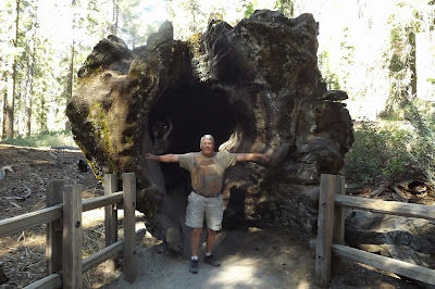
Another enterprising land owner made a tunnel through this tree and charges $5 to drive through.
Because the Redwood National and State Park is owned by  both the state and fed, it wasn't shut down so we took a primitive one-lane road through the park, stopping from time to time to walk around and marvel at the massive size of these ancient trees.  The air in the forest smells so clean and pure, I wish I could bottle it.
 
Majestic and Magnificent

PLAN B - Oct. 13 - 16
Our original plan was to visit Yosemite National Park after seeing the Redwoods, but Yosemite is shut-down so we need to have a Plan B.  Jim suggested we head east to Mount Shasta.  Sunday we left the Pacific coast and drove east on the winding and twisty mountain Highway through the Trinity National Forest.  Our average speed was about 35 mph and it took us 3 hours longer than we had planned to reach Mount Shasta City.  By the time we got to our campsite at Lake Abrams RV Park, it was cocktail hour and we both were ready for a Manhattan.

MAGICAL AND MYSTICAL
We soon met other campers and long-term residents at the campground.  Many had come to the area to experience the spiritual, metaphysical, and energetic aspects of the mountain and surrounding area.  We had some interesting conversations with some of our fellow campers about the powerful energy and spiritual nature of Mount Shasta, the hot springs, lakes, and vortex sites surrounding the mountain.
The view of Mount Shasta from Lake Siskiyou.
WERE HEAVEN MEETS EARTH
Mount Shasta is over 14,000 feet high, and is said to be one of the 7 sacred mountains of the world.  On a clear day Mount Shasta can be seen from Crater lake which is 150 miles away.

Monday we drove up over 7,000 feet on the southwest side of the mountain.  There are several places to park at trailheads and hike on the many trails through the forest.  Apparently, the Shasta-Trinity U.S. Forest Service Employees are a little rebellious and didn't quite buy into the whole shutdown thing, as the gate was open, as well as the bathrooms unlocked.  The road ends at the Old Snow Bowl and is a popular starting point for those adventurous souls who attempt to climb to the summit.  Only 1 in 3 climbers succeed in reaching the top.
Map of routes to the summit.

The Old Snow Bowl
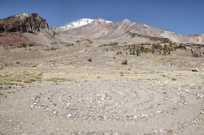
Labyrinth at the Old Snow Bowl area.
Labyrinth in the foreground, Old Snow Bowl in the background. 
We spent some time shopping and exploring the free spirited town of Mount Shasta City and couldn't help but notice how everyone we met was smiling, friendly, respectful, and just plain happy to be there.  The loving and peaceful energy here is almost palpable.  I noticed that all my senses seemed more alive; colors more vibrant, sounds clearer, sense of smell more distinct, and even the taste of food burst with more flavor .

As annoyed as I've been with the government shut-down, and disappointed with their closing national parks and monuments we wanted to see, I'm now grateful that we had to go to Plan B and took the detour to Mount Shasta.  This was a truly memorable and unexpected experience.

Monday, October 14, 2013

MORE SHUT-DOWN AND OREGONIANS

A BEND IN THE ROAD - October 8
We left the stunning ocean vistas of the west coast of Oregon and traveled east to Bend.  Driving over a mountain pass we ran into snow.  We have heard nothing but rave reviews of the beauty of Bend's snow capped Mount Bachelor, and the 300 days of sunshine they receive each year.  Unfortunately, we managed to visit on the few days that the sun wasn't shining; it was raining, and the mountains were covered in clouds.  We stayed one night and moved on south to Crater Lake hoping that the government shut-down would be over and we'd be able to visit Crater Lake National Park.

RIVERS, VOLCANOS, AND LAKES - October 9 & 10
We stayed 2 nights in the little mountain town of Prospect at the Crater Lake RV Park.  Prospect is in the middle of the national forests with the Rouge River running through the area.  Since the government shut-down was still going, we weren't able to see Crater Lake, but did see Diamond Lake, waterfalls, and evidence of the volcanic action that took place over 7,000 years ago and formed the stunning and magnificent sights in this area.  We hiked  past several "closed due to government shutdown" signs to several waterfalls, and along the Rouge River Gorge where the river runs through a lava tube and forms a natural bridge. 
The highway was open but the gate to the entrance of Crater Lake kept us out.

Rouge River Gorge

The Natural Bridge

Even the pit toilets were locked up.  We met a woman on the hike along the river gorge who said "well, if I didn't have to go to the bathroom before, all this rushing water is making me want to go now".  Behind the restrooms, there was "evidence" of people who had to "go".  We were sorry for the inconvenience too. 

A lovely spot for a picnic over-looking Diamond Lake and distinct volcano, Mount Bailey.

They even furloughed, wrapped, and tied up poor Smokey the Bear.
 He isn't allowed to tell people "Only You Can Prevent Forest Fires".
LAUGHING WITH THE LOCALS
Prospect's only bar, The Trophy Room, had comedy night on Thursday.  We showered, put on some clean blue jeans, and headed out for a night on the town.  About 25 locals (some furloughed forest service employees) showed up to listen to Chris, the comedian, who had come all the way from the big city of Eugene.  He started his show by asking if we wanted to hear the "clean" show or the "dirty" show.  The crowd shouted "DIRTY", so I won't be repeating any of his jokes or stories.  He was funny and we enjoyed a lot of laughs, some brews, and conversation with the locals and their take on the government shut-down.  One thing I have to say about the Oregonians we've met on this trip, they are friendly and generous.
Chris: "Hey, Jim and Connie did you hear the one about..."

Cheers from The Trophy Room
Tomorrow we leave for Crescent City in Northern California to see the redwoods.

Tuesday, October 8, 2013

SCREAMING, SURFING, SEA LIONS, AND SIGNS

Central Coast - Oct. 6 - 7
 
I SCREAM, YOU SCREAM, WE ALL SCREAM FOR ICE CREAM!
Before leaving the Tellimook area we had to stop, one more time, and stand in line for an ice cream cone at the Tellimook Cheese Factory. 
YUM!
 
MINNESOTA SURFING
Stopping at the popular beach town of Ocean City, OR, we met a young woman from Minnesota.  When I saw a surf board on the roof of a car with Minnesota plates, we just had to ask..."where are you from in MN?".  She said she was from the little town of New Munich, near St. Cloud, but she has been out here for awhile.  We chatted with her saying a lot of "ya sures and you betchas", then said our good-byes and continued on to new sights.
Ocean City Beach and huge sand dune.

Surfers at Hay Stack Rock in Ocean City

Those little specks on the huge sand dune are people climbing up to run or sand surf down the giant dune.

CENTRAL COAST
We stopped several times at scenic vistas on our way down the Central Coast. The views of surf pounding the rugged rock cliffs and the sandy beaches along Hwy 101 is stunning.


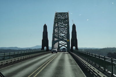
Several Historic Landmark bridges, designed by Conde McCullough
in an Art Deco Style, cross the rivers flowing into the Pacific.
SCREAMING AT THE DEVIL
One interesting spot we stopped at was called The Devil's Punchbowl.  Waves come into this crack in the basalt rock and create some mighty fine wave and spray action.  This is a Federal site and should have been closed due the Government shut-down, but thanks to some local volunteers who decided to protect it from vandalism, clean the restrooms, and keep it open (with no entry fees being collected) we were able to get in to see this wild sight.
See the little specks of blue and green toward the bottom right side of the picture?
  A woman was taking a picture of two girls at the Devil's Punchbowl when the
 spray from a  big wave soaked them.  Their screaming was hilarious.

PARKING IN THE RAIN FOREST
We are staying 2 nights at the Carl G. Washburne State Park.  Although the sun is shining, it feels like we are in a rain forest with massive ferns, mushrooms and moss growing on everything.  We strolled down the 1/2 mile trail along China Creek through the lush forest and under the Hwy 101 bridge to the ocean.  I woke up in the middle of the night to the sound of rat-a-tat-tat on the roof and had to get up to retract our bedroom slide-in before the rain flooded us again.
Trail to the beach through the lush rain forest.

Logs piled up at the mouth of China Creek.

A GUIDING LIGHT - Oct. 7
Today we explored more of the Central Coast and stopped at Heceta Head Lighthouse, which is said to be the most photographed light house on the Oregon Coast.  This National Landmark is run by the State of Oregon and the U.S. Forest Service and is open for tours Memorial Day through Labor Day.  We didn't get a tour, but did walk around the grounds because the State of Oregon is still in business and not part of the Government shut down.
This beautiful Queen Anne style duplex was once the home of the
 former Lighthouse Keepers and their families; it's now a B & B.
 
The Heceta Head Lighthouse has been in use since March 1883 and is still in
operation although electric automation ended the need for lighthouse keepers.
SEA LION CAVE
One of the largest sea caves in the world is located on Oregon's central coast, and is the breeding ground and home to 80,000 seal lions (well, that's their story and they're sticking to it).  Before we bought our tickets we were told that the sea lions were out in the ocean feeding so we wouldn't see any of these huge animals in the cave.  It was still worth the trip down 200 feet in the elevator to the cavern which covers 2 acres, with a vaulted dome rising 125'.  We stood in this massive area seeing and hearing the waves rushing in and out of the cave.  Had there been sea lions lulling around, it would have been perfect.
View from the Sea Cave toward the Heceta Head Lighthouse
 SIGNS OF THE TIMES
Didn't get to see (or pay the fee) at the Oregon National Sand Dunes Recreational Area


Driving up and down the coast highway there are warning signs "Entering Tsunami Hazard Area"
and "Leaving Tsunami Hazard Area".  It's always good to know where the evacuation route is.
Debris from the Japan tsunami is no longer evident.  Pictures of the massive amount of stuff that made
its way to our west coast is unbelievable.  Thank you to the volunteers who cleaned up the beaches.