Before leaving the Tellimook area we had to stop, one more time, and stand in line for an ice cream cone at the Tellimook Cheese Factory.
 |
| YUM! |
Stopping at the popular beach town of Ocean City, OR, we met a young woman from Minnesota. When I saw a surf board on the roof of a car with Minnesota plates, we just had to ask..."where are you from in MN?". She said she was from the little town of New Munich, near St. Cloud, but she has been out here for awhile. We chatted with her saying a lot of "ya sures and you betchas", then said our good-byes and continued on to new sights.
 |
| Ocean City Beach and huge sand dune. |
 |
| Surfers at Hay Stack Rock in Ocean City |
 |
| Those little specks on the huge sand dune are people climbing up to run or sand surf down the giant dune. |
CENTRAL COAST
We stopped several times at scenic vistas on our way down the Central Coast. The views of surf pounding the rugged rock cliffs and the sandy beaches along Hwy 101 is stunning.
 |
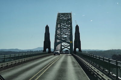
| Several Historic Landmark bridges, designed by Conde McCullough in an Art Deco Style, cross the rivers flowing into the Pacific. |
One interesting spot we stopped at was called The Devil's Punchbowl. Waves come into this crack in the basalt rock and create some mighty fine wave and spray action. This is a Federal site and should have been closed due the Government shut-down, but thanks to some local volunteers who decided to protect it from vandalism, clean the restrooms, and keep it open (with no entry fees being collected) we were able to get in to see this wild sight.
PARKING IN THE RAIN FOREST
We are staying 2 nights at the Carl G. Washburne State Park. Although the sun is shining, it feels like we are in a rain forest with massive ferns, mushrooms and moss growing on everything. We strolled down the 1/2 mile trail along China Creek through the lush forest and under the Hwy 101 bridge to the ocean. I woke up in the middle of the night to the sound of rat-a-tat-tat on the roof and had to get up to retract our bedroom slide-in before the rain flooded us again.
 |
| Trail to the beach through the lush rain forest. |
 |
| Logs piled up at the mouth of China Creek. |
A GUIDING LIGHT - Oct. 7
Today we explored more of the Central Coast and stopped at Heceta Head Lighthouse, which is said to be the most photographed light house on the Oregon Coast. This National Landmark is run by the State of Oregon and the U.S. Forest Service and is open for tours Memorial Day through Labor Day. We didn't get a tour, but did walk around the grounds because the State of Oregon is still in business and not part of the Government shut down.
 |
| This beautiful Queen Anne style duplex was once the home of the former Lighthouse Keepers and their families; it's now a B & B. |
 |
| The Heceta Head Lighthouse has been in use since March 1883 and is still in operation although electric automation ended the need for lighthouse keepers. |
One of the largest sea caves in the world is located on Oregon's central coast, and is the breeding ground and home to 80,000 seal lions (well, that's their story and they're sticking to it). Before we bought our tickets we were told that the sea lions were out in the ocean feeding so we wouldn't see any of these huge animals in the cave. It was still worth the trip down 200 feet in the elevator to the cavern which covers 2 acres, with a vaulted dome rising 125'. We stood in this massive area seeing and hearing the waves rushing in and out of the cave. Had there been sea lions lulling around, it would have been perfect.
 |
| View from the Sea Cave toward the Heceta Head Lighthouse |
 |
| Didn't get to see (or pay the fee) at the Oregon National Sand Dunes Recreational Area |
 |
| Driving up and down the coast highway there are warning signs "Entering Tsunami Hazard Area" and "Leaving Tsunami Hazard Area". It's always good to know where the evacuation route is. |


No comments:
Post a Comment